Wolfe’s Neck Center (WNC) is seeking to transform our relationship with food and farming for a healthier planet. To help achieve this, WNC is researching soil carbon sequestration as a way to reduce agriculture’s greenhouse gas emissions and impact on our planet. Read on to learn more about soil carbon sequestration at WNC.
Carbon sequestration has risen in popularity as a means of removing excessive CO2 from the atmosphere. Plants naturally take in carbon when they photosynthesize, storing it in the soil. However, this is a long-term process, and scientists have found that it takes up to 100 years to ensure that the carbon is stabilized in the soil. Encouraging plant development has been a method of mitigating climate change by increasing carbon sequestration. At Wolfe’s Neck Center (WNC), we have been conducting on-farm research to measure the carbon in our soils to see how the stores fluctuate over time.
The measurement of soil organic carbon (SOC) is a complex and contested process that boils down to two measurements: total carbon and bulk density. Total carbon is usually measured in a laboratory using the dry combustion method, whereby a soil sample is heated and all carbon compounds are decomposed and converted into measurable carbon oxides. To estimate the SOC in an area of land, bulk density measurements can be used to adjust total carbon levels for varying soil densities / concentrations across the soils. Both processes are time-consuming and labor-consuming, which makes measuring carbon on the farm a challenging process.
Because the measurement of SOC stores is such an intense process, people have begun to look to environmental indicators of SOC sequestration capacity. Soil type is a leading determinant, as more clay-heavy soils can sequester more carbon. Similarly, land cover can determine potential. For example, large trees pull more carbon out of the atmosphere, while barren land does not pull much at all. Other factors like land gradient, temperature, and precipitation also affect plant establishment and growth, and therefore contribute to sequestration rates. Spatial analysis helps us understand where sequestration is most feasible, and perhaps where carbon removal practices and management strategies should be implemented.
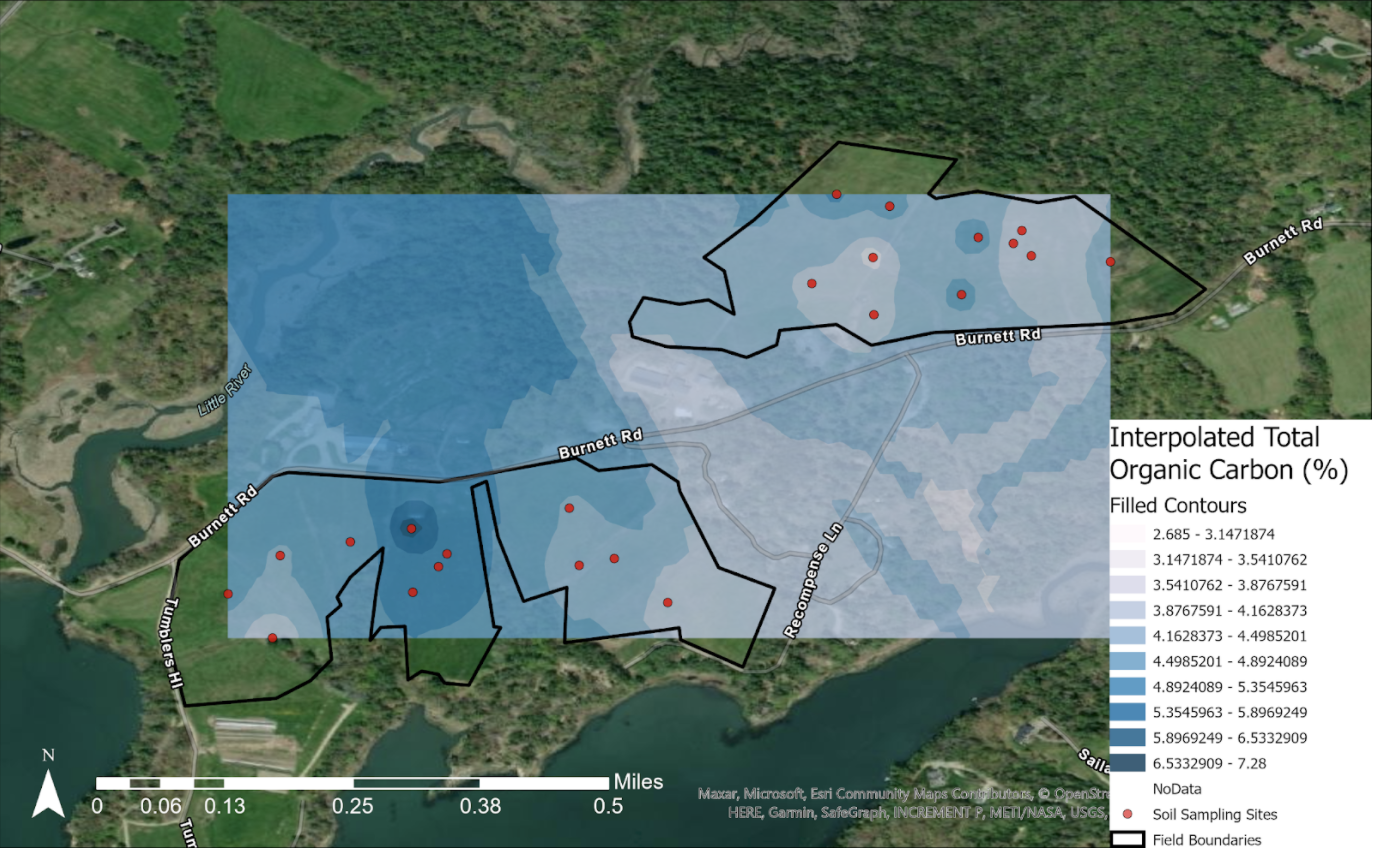
In 2021, we collected upwards of 100 soil samples for various purposes at Wolfe’s Neck Center. This map of Wolfe’s Neck shows the interpolated soil organic carbon levels for the Brocklebank and Bay fields. Interpolation refers to the mathematical process of inferring values based on inputted data. In other words, the red points indicate points where we took soil samples and had them lab tested for actual SOC levels.
The shades of blue around the points illustrate expected carbon stores for the surroundings. This map indicates that there is more SOC concentrated around Middle Bay. This makes some sense because this is our primary grazing pasture; the land is particularly rich thanks to cow manure. This area also is also relatively well draining, allowing for water to percolate through the soil as well as run off when there is an excess.
Gathering this data helps the staff at Wolfe’s Neck Center understand the complex processes happening on WNC’s land and how using regenerative agricultural practices can better support soil carbon sequestration and stabilization on Wolfe’s Neck. WNC also serves as a proving ground for technology and best practices, so that we can then share with other farmers who are seeking to be part of the solution to mitigate climate change through the Maine Soil Health Network.
Soil carbon sequestration is just one way that Wolfe’s Neck Center is working on agriculture being a solution to climate change. Learn more about our other on-farm research here.
← Back to Blog