Ag Tech Tools: Farming in a Modern World
By Cora Kerber, Research & Communications Intern
Wolfe’s Neck Center has a rich history of innovation and experimentation in farming and food systems, and the future of farming depends on this resilience. By integrating technology into our daily farm operations and management, we can build soil health on farms in the face of climate change. Take a look at some of our newly implemented tech tools used to collect and manage on-farm data:
FarmOS: Digital Recordkeeping
FarmOS is our primary tool for farm management, planning, and record keeping. It is a web-based application that was developed by a community of farmers, developers, researchers, and organizations to provide a standard, open source platform for agricultural data collection and management. This means that data is shareable, not privatized. This approach allows for collaboration and greater transparency of processes on farms across the globe.
Here at Wolfe’s Neck Center, we use FarmOS to track animal movements, document seedlings and plant growth, capture vegetable and hay harvest data, and store on farm research data. This information can then be used to advise future planning, help farm management decisions, and support greater research efforts.
FarmOS is affordable and accessible to all farmers, and has the backbones for huge scaling potential. What would have normally taken multiple apps, Excel spreadsheets, or written records can now be recorded and stored in a single application. In the next few years, FarmOS could support documentation for organic or regenerative agriculture certification, analyze farm-level greenhouse gas emissions, support better economic decisions on the farm, and connect to ecosystem service markets to pay farmers for the soil carbon they capture in the ground or the biodiversity they support.
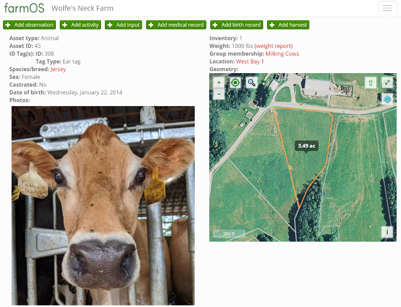
 Meet Fawcett, a 6 year old Jersey. Each of our milking cows have an individual profile on FarmOS that enables us to keep tabs on all of our cows, create animal groupings, and track herd movements and grazing.
Google My Maps: Pasture Mapping
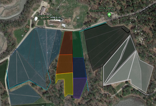
In addition to tracking animal movements through FarmOS, we also visually map out the week’s grazing plan using Google My Maps. Since we practice intensive rotational grazing, each morning and evening after milking, our cows walk out to the pasture to snack on the myriad of grasses and legumes. As an organic dairy, our cows are required to have at least 30% of their diet from grazed forages during the grazing season. Right now, as much as 50-70% of their diet comes straight out of the pastures!
The farmers set up paddocks (small areas of farm fields) for cows to graze each day, but they need to determine how big to make it so the cows eat enough nutrients. They calculate paddock size by estimating the amount of forage dry matter in the pastures and taking into account our herd size. Using Google My Maps allows our livestock team to know which paddock the cows should be in each morning and evening. Eventually, we will be able to track our whole grazing plan directly in FarmOS.
 Each week, our dairy herd “follows the rainbow” while chomping down on grasses and legumes. Maps like this one help keep our team organized when moving our dairy herd twice a day. Over the course of about a month, our cows will rotate through each pasture and then start all over again once the forage has grown back.
Vence: Tracking Animals Movements
A tech tool we will soon be using on the farm is animal movement tracking. Vence is a virtual fencing company founded to improve the affordability and availability of sustainable animal protein. Vence technology combines audio cues with GPS, allowing farmers to control animal movements by creating virtual boundaries made up of GPS coordinates. Through their herd manager application, virtual fences could replace the hassle and hard work of setting up electric fences each week. They are created by a simple swipe of a finger.

While the technology is not quite fine-tuned enough to be able to set up the virtual fencing here at Wolfe’s Neck Center, we will be using Vence collars on our dairy herd to track animal behavior and movement. During the B3 research project in the fall, these collars will provide us with data on each animal’s location at any given time. This will allow us to accurately track movements, enabling us to see where the herd congregates out in the pastures during grazing. This data will inform our soil sampling methodology throughout the course of the B3 study.
Why Invest in Tech?
In some ways, farming is a back-to-roots connection to the land and likely doesn’t conjure up images of modern day technology. That is changing, and businesses, organizations, researchers, farmers and ranchers around the world are advancing the capabilities of agriculture to withstand effects of climate change. With this in mind, in July 2019 Wolfe’s Neck Center became one of the founding partners in a collaborative effort to address these needs. Open Technology Ecosystem for Agricultural Management (OpenTEAM) was created to put the best locally relevant agricultural knowledge into the hands of farmers and producers to support building healthy soils and capturing carbon. In practice, this requires collecting more high-quality data on farms and sharing it with researchers. As a hub farm for OpenTEAM, Wolfe’s Neck Center will test and develop various tech tools and methods, providing feedback to the OpenTEAM community throughout the process.
← Back to Blog